
Context
Genealogical source data is a prerequisite for practising genealogy and for that reason the GSSA runs several projects within certain focus areas: a person’s life, in its most basic form, is defined by the events associated with birth and death. The first focus area, therefore, centres around death related information. This includes cemetery locations, cemetery records, headstones, funeral letters and a virtual space for remembering loved ones (“in memorium”).
Overview of the Cemetery Recording Initiative
This is an initiative of the Genealogical Society of South Africa (GSSA), spearheaded by Peter and Beverley Moss and Riana le Roux.
The goal is to preserve the genealogical information contained in cemeteries of South African interest and make the information accessible to genealogy researchers.
The aim is to preserve information by managing the collection, recording, processing and safekeeping of cemetery data. As such, the genealogical information recorded includes birth, death and burial data, plus any personal historical data (e.g. occupation, marriage or any other family relationships) contained in the cemetery records.
-
The data is collected from all types of cemetery sources, such as gravestones, burial registers, memorials and cremation memorial plaques.
-
The project covers all cemetery data of South African interest, inside and outside South Africa.
-
A prime focus of the project is the collection of information from the many farm cemeteries that exist throughout South Africa. These have no burial registers and the gravestones are subject to neglect and damage, unlike town cemeteries that are now increasingly also under threat.
The following three projects are interlinked and interdependent. Together they constitute the GSSA Cemetery Recording Initiative: the Cemetery Locations project; the Cemetery Records project; and the Gravestone Photos project.
PROJECT Cemetery Location
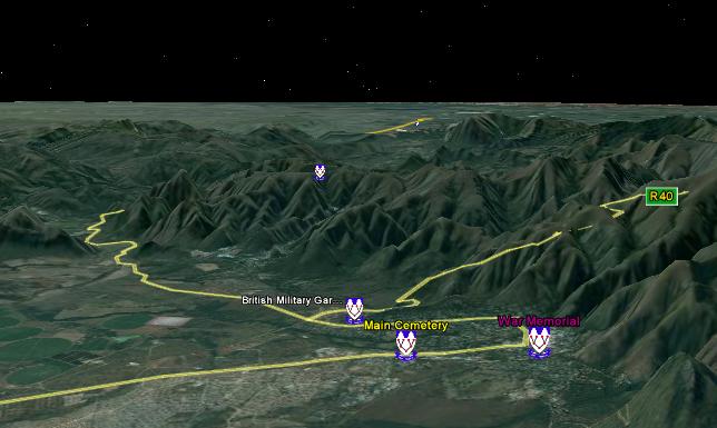
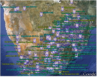
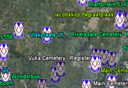
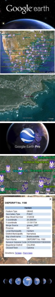
Technologies such as Google Earth and GPS (global positioning system) coordinates make it easy to keep track of cemeteries already recorded or not and farm cemeteries, which are otherwise difficult to locate. Once set up and loaded with the appropriate .KMZ file, the Google Earth display shows cemetery locations relevant to the cemetery related projects and indicate their position with an appropriate icon. Two sets of information are available: GSSA Cemeteries (the indexed cemeteries) and 50K Cemeteries (the unindexed cemeteries). The related KMZ files can be downloaded via the Genza.org.za website.
PROJECT Cemetery Records
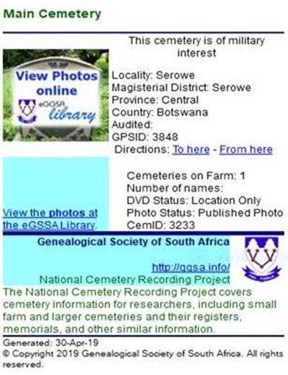
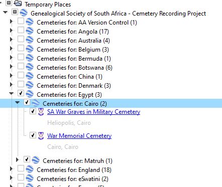
The Cemetery Records project transcribes the information from various sources and takes-on these records on inhouse databases, on a continuous basis. This provides the information to produce two indices: a Cemetery Index and a Gravestone Transcription Index.
An annual snapshot of the Gravestone Transcription Index is published as an edition. The latest, Gravestone Transcription Index, Edition 21, published in March 2023, contains 953 225 names from 3 196 cemeteries. This edition of the Gravestone Transcription Index can be procured as a digital download via the OnlineShop, and contains the full index, as at the date of the edition.
Alternatively, the Gravestone Transcription Index, updated on a continuous (monthly) basis throughout the year, is also available in the following way: Individual records of the Gravestone Transcription Index can be procured through the WebShop – it provides a search engine to select specific records and procure them on a token basis.
Extracts (Excel spreadsheets) of the Cemetery Index are available on the Genza website, free of charge. It is used to manage the recording effort and contains three main areas: cemetery names, documents and cemetery locations.
PROJECT Gravestone Photos
The Gravestone Transcription Index is complemented by captioned photographs of the gravestones. These gravestone photographs are made available in alphabetical albums, searchable by name, cemetery, etc. – free of charge on the graves-at-eggsa.org website. These albums currently contain over 925 000 photos, with many more photos still to be processed.
Various sets of guidelines are available, for example on planning a trip to a cemetery, photographing gravestones, etc.
Invitation and request
In addition to cemetery recording efforts at the various GSSA branches, we have many volunteers who record data and assist with data processing. You are welcome to contribute to the initiative – the invitation is open to the public. We do have some recording guidelines that should be followed to record information for this project. If you are interested in helping with photographing and transcription of Cemetery Registers, or adding captions to gravestone photographs, please contact Peter MossThis email address is being protected from spambots. You need JavaScript enabled to view it.or Riana le Roux This email address is being protected from spambots. You need JavaScript enabled to view it..
More information
This document corresponds with the GSSA’s website (Genza.org.za). A project overview for each of these projects is provided, with supporting information that is generally downloadable and with extensive links to relevant pages and websites.
Actions
 Project leaders Peter and Beverley Moss